
Adolf Munkel Trail Guide: Hiking the Base of the Odle Mountains in Val Funes
If you want to feel very small in the best way possible, this is the hike for you. The Adolf Munkel trail basically hugs the base of the Odle Mountains, so you aren’t just looking at the mountains from a distance, you’re right there under the sheer limestone cliffs of the Geisler peaks. It’s one of the most impressive walks in the Val Funes (Villnöß).
What to Expect on the Adolf Munkel Trail
The beauty of this route is the variety. It’s a mix of shady woods, open meadows, and views that make you want to stop every five minutes to take a photo. While the path is generally well-maintained, it’s not just a stroll through a park. You’ll be navigating a bit of everything, from soft forest floors to rocky sections right under the peaks.
Trail Overview
Distance: 9.5km (Loop)
Elevation Gain: 582m
Difficulty: Easy to Moderate
Best Season: June to September for dry trails; October for autumn colours. In October, some sections, especially shaded parts in the woods are icy and slippery. Bring proper hiking shoes with a good grip or hiking pools.
How to Get to the Adolf Munkel Trail: Parking and Logistics
We headed for the Zanser Alm Parkplatz (also known as the Zans car park). It’s a massive car park split into a few different sections. As Val di Funes is so popular (and the valley is narrow), they’ve set up a system to prevent major traffic jams.
Here is how to handle it without losing your head:
The Online Booking “Golden Ticket”
You can actually book your parking ticket online in advance. It’s worth doing if you know exactly which day you’re going. Only a limited number of tickets are available online. If it says they’re sold out, don’t panic. It just means the online quota is full, not the actual car park.
You can reserve your space online on [Parking Zans online reservation].
The Ranui Traffic Lights (Green means Go)
If you are visiting in off-peak season, the Traffic Light system is rarely an issue then, and you won’t need to set a 6:00 AM alarm just to secure a parking spot. However, if you are tackling the Adolf Munkel Trail in the height of summer, the early bird rule is non-negotiable.
Our base was just a 12-minute drive from the Zans car park, and honestly, it made the whole experience much more relaxed. Being that close is a massive win because it allows you to get to the trailhead before the traffic starts. You can find more details of our accommodation and Val di Funes itinerary [here].
As you drive through the village of Ranui, keep your eyes peeled for the parking lights. This is the Italian way of managing the mountain traffic:
Green Light: You’re in luck. There is space at the Zans car park. You can drive right up and pay at the machine on-site.
Red Light: The car park at Zans is full. Unless you have one of those pre-booked online tickets, they won’t let you up.
Plan B: St. Magdalena and the Bus
If you see the red light and didn’t pre-book, just head for the alternative car parks in St. Magdalena (look for the Ranui, Putzen, or Filler lots). From there, you can hop on the Public Bus Line 330. it runs to the Zans car park every hour.
The Adolf Munkel Trail Route: Our Recommended Geisler Alm Loop
You spend a lot of time in the Dolomites looking at the Odle mountains from a distance, but walking the Adolf Munkel feels like you’ve been invited backstage.
One minute you’re in the quiet, mossy woods, and the next, you emerge into these wide-open meadows where the limestone peaks are just there, towering thousands of feet above you. It’s the kind of scale that a camera can’t quite capture. You really have to stand at the base of those jagged giants to understand their size.
The Shorter Loop (The one we did)
One of the best things about the Adolf Munkel Trail is its flexibility. If you want to see the best of the Odle Mountains without ending the day completely wiped out, the 9km loop is a good choice. It takes roughly 3 to 4 hours from start to finish.
The Extended Stretch (For the ambitious)
If you’re feeling particularly energetic, you can embark on the 17km trail. This route pushes further along the base of the mountains toward Val Gardena and Alpe di Siusi until you reach Rifugio Malga Brogles (Brogles Alm).
October Hiking: A Word of Warning
If you are planning to tackle this loop in October, you need to be a bit more strategic than a summer hiker.
The initial section of the trail that leads you away from the Zans car park is deep in the woods and gets very little sunlight. By October, this part of the path is often incredibly icy.
Even if it’s a beautiful, crisp day in the open meadows, the woods can be a bit of a skating rink. Take your time, wear proper hiking boots with good grip, and don’t be afraid to take it slow.
Our Classic Loop Trail
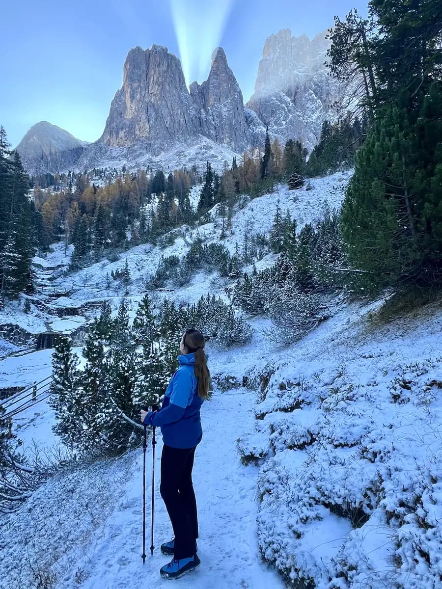
The journey begins at the Zanser Alm car park. We set off on Trail 6, which immediately takes you into a thick, mossy forest. If you’re visiting in October, this is where you need to keep your wits about you. As you continue the steady climb, the trail follows the St. Zenon stream.
Eventually, the trees begin to thin out, and you’ll find yourself emerging onto the higher slopes where the landscape starts to shift from dark forest to wide, rocky meadows.
Walking Beneath the Jagged Giants
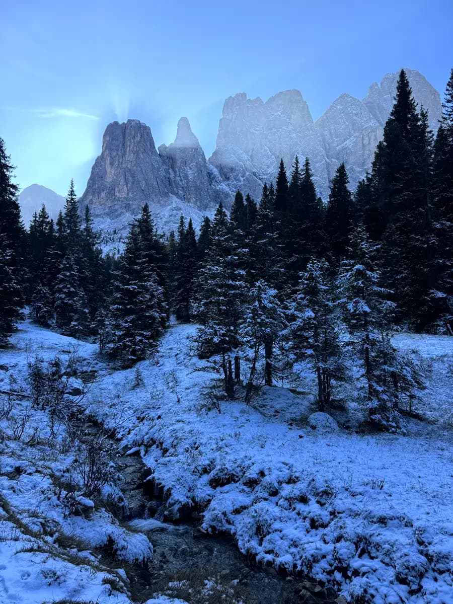
Once the forest opens up, you’ll join Trail 35, which is the official Adolf Munkel path. he scale is impossible to capture in a photo; you feel tiny against the backdrop of peaks like Sass Rigais and Furchetta.
You’ll walk past massive boulders that have tumbled down from the peaks over centuries, now covered in moss and snow.
The 180-Degree Reveal: Emerging at Malga Casnago
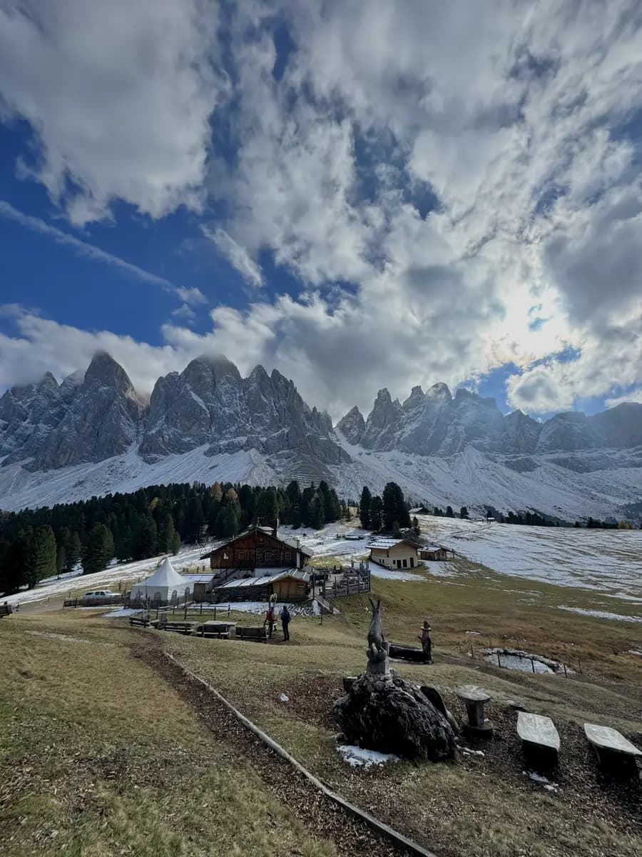
Just as you think the trail can’t get any more impressive, you walk out of the forest and into a massive, open alpine meadow heading toward Malga Casnago (also known as Gschnagenhardt Alm).
I remember turning around at this exact point and just stopping. You’re suddenly faced with a 180-degree view of the Odle peaks that is, quite honestly, unreal. Because you’ve been hugging the base of the mountains, you don’t realize how much of the range you’ve actually covered until you stand in this open space. Seeing those jagged limestone giants stretching across the horizon in every direction makes you feel very small in the best way possible. It’s one of those “pinch-me” moments where you realize why the Adolf Munkel path is world-famous.
The Best Lunch Spot in Val Funes: Geisler Alm and the Walk Back
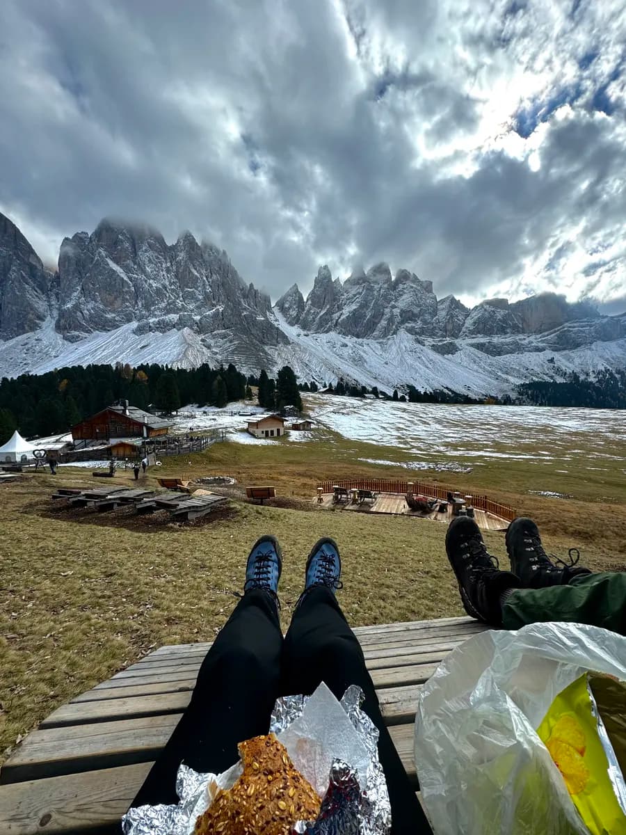
After soaking in that 180-degree panorama, it’s a short, scenic stroll to Rifugio Geisler Alm. If you’ve seen a photo of the Val Funes, it was likely taken here. This is the spot known for its sprawling green lawns and those iconic wooden lounge chairs facing the peaks. It feels like a natural amphitheatre where the mountains are the main event.
We had brought our own paninis and snacks for lunch, so we headed up to one of the wooden sunbeds. Sitting there, watching the clouds drift in between the Odle mountains, was surreal.
Rifugio Geisler Alm was open in October, which isn’t always a guarantee in the Dolomites. If you don’t fancy packing your own lunch, you can easily grab a proper hot meal or a drink here. Having the option of a warm soup or a coffee is a great backup, especially with the cold mountain air.
It was cold, but once you have enough layers on, it’s perfectly doable. We were glad for our thermals and extra jackets; they meant we could actually sit and enjoy the view rather than rushing back to the warmth of the car.
When you’ve finally had your fill of the view, take the path turning left (Trail 36) to start your descent toward Malga Dusler Alm for that final strudel and Hugo Spritz…
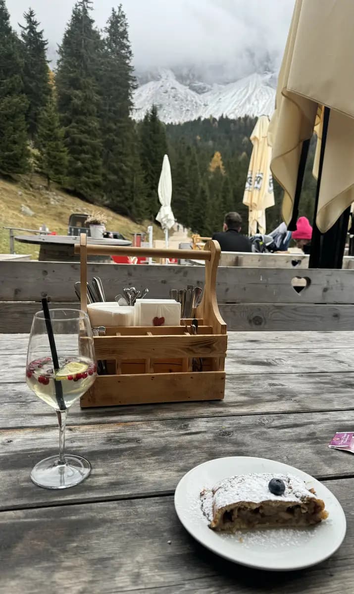
The Final Descent: Finding the Strudel at Malga Dusler Alm
When you’ve finally pulled yourself away from the view at Geisler Alm, the journey back to the car is a much more relaxed affair. With your back to the rifugio, you’ll want to head to the left to pick up Trail 36.
One of the best things about doing the loop in this direction is the change in perspective. While the ascent was all about the “jagged giants” looming over us, the walk back toward Malga Dusler Alm opens up the whole horizon.
About 40 minutes into this descent, we arrived at Malga Dusler Alm. While Geisler Alm is the “famous” one, Malga Dusler Alm is where you go for a bit of peace and quiet. It’s a much more traditional, tucked-away hut that feels like a hidden gem.
Stopping here for a Hugo Spritz and a warm slice of apple strudel was the highlight of the afternoon. The strudel was delish.

Navigating the Icy Woods to the Car Park
The last leg of the loop from Malga Dusler Alm back to the Zans car park is usually a straightforward 30-minute stroll, but in October, it can turn into a bit of a mission.
Because of the icy conditions, this final stretch actually took us about an hour. The main trail path was too slippery that it was actually safer to head off the main path and into the woods to find some grip on the pine needles and dirt.
A Pro Tip for Autumn Hikers
If you find yourself on a trail that’s turned to solid ice, don’t try to “brave it” on the main track. Moving a few feet into the trees where the ground is more uneven and covered in forest floor debris gives you much better traction.
Summer vs. Autumn: If you’re visiting in the hotter months, you’ll likely fly down this path in half the time. But in the shoulder season, you need to budget that extra hour just in case.
In My Rucksack: Packing for the Peaks
October in the Dolomites is a mixture of all four seasons. One minute it’s breezy and cold and the next you are warm in the sun. I highly recommend “The Onion Method” lots of thin, high-quality layers that you can peel off or pile on as the weather shifts.
The Layering System: I wore body warmers from both UNICLO and Primark.
For my fleece, I used [The North Face Denali Jacket]. It’s a classic for a reason. It’s properly warm without being too bulky to fit under a shell. I went for the Chlorophyll Green which looked fantastic against the autumn colours, but more importantly, it kept me warm at the summits.
Your top layer needs to be a shield. I used [The North Face Diablo Dynamic Jacket]. It’s a solid, reliable rain jacket that is completely windproof and waterproof. It’s lightweight enough to shove into your pack when the sun comes out, but heavy-duty enough to handle a proper mountain downpour.
Sturdy Hiking Boots: You need something waterproof with a good grip. The trails on Seceda, Mount Pic and Adolf Munkel are slippery, especially if there’s a bit of morning frost or loose scree. I’ve been wearing [The North Face Verto GORE-TEX Alpine Mid Boots] and they have been a game-changer. They have a Vibram sole which is fantastic for gripping and the Gore-Tex lining is a lifesaver when you inevitably end up crossing muck and snow.
The Break-in Tip: If you’re getting a fresh pair for your trip, wear thick socks for that first outing and keep a few Compeed plasters in your bag just in case. Mine needed that initial hike to soften up, but once they were worn in, they were very comfortable. Now, I can spend all day in them without a second thought.
The Accessories: Bring gloves, a warm hat (beanie), and sunglasses. Even on a blue-sky day, the wind at the ridgelines is sharp. The high-altitude glare is also incredibly strong, so your eyes will thank you for the protection.
Planning Your Dolomites Adventure?
The Adolf Munkel Trail is just one piece of the puzzle. If you’re trying to figure out how to navigate the rest of the Val di Funes or where to head next without spending ten hours a day in the car, I’ve got you covered.
- Check out my full [Dolomites Itineraries]: I’ve mapped out the best ways to see the peaks while avoiding the worst of the tourist logjams. Whether you have three days or ten, these guides will help you get the most out of your time in the mountains.
- Explore more [Dolomites Hikes]: From the iconic ridgeline of Seceda to the hidden corners of Mount Pic, you can find all my detailed trail guides and real-talk safety tips right here.